You are here
Journal Club for June 2022: Computational mechanics for local-scale modelling of coastal hazards
In 2016, our colleague (Prof. Ahmad Elbanna) addressed one such extreme event (namely, earthquakes and the associate rupture physics). In this journal article, I will be focusing on two other extreme events, namely tsunamis and storm surges and some of the modelling efforts to address these coastal hazards. While both these events have their characteristics related to the physics of the event, similar modelling tools and techniques have been used to address both these hazards. One of the biggest challenges of the problem is the multi-disciplinary nature that involves engineers, mathematicians, geophysicists, environmental agencies, economists and even administrators from the city council.
Background
The coastal area remains one of the most active areas on the planet. It includes over 25% of the world population within a 100 km range of the coast, while about 10% live below the mean sea level. In addition, this is also home to diverse flora and fauna like coral reefs, mangroves, beaches and so on. According to the US census bureau, about 29% of the US population lives in the coastline counties, including about 41M in the Atlantic and 32M in the Pacific counties. In contrast, only about 47M lived in coastline counties in the 1960s. This is about a 25M+ increase in the population over the last 60 years.
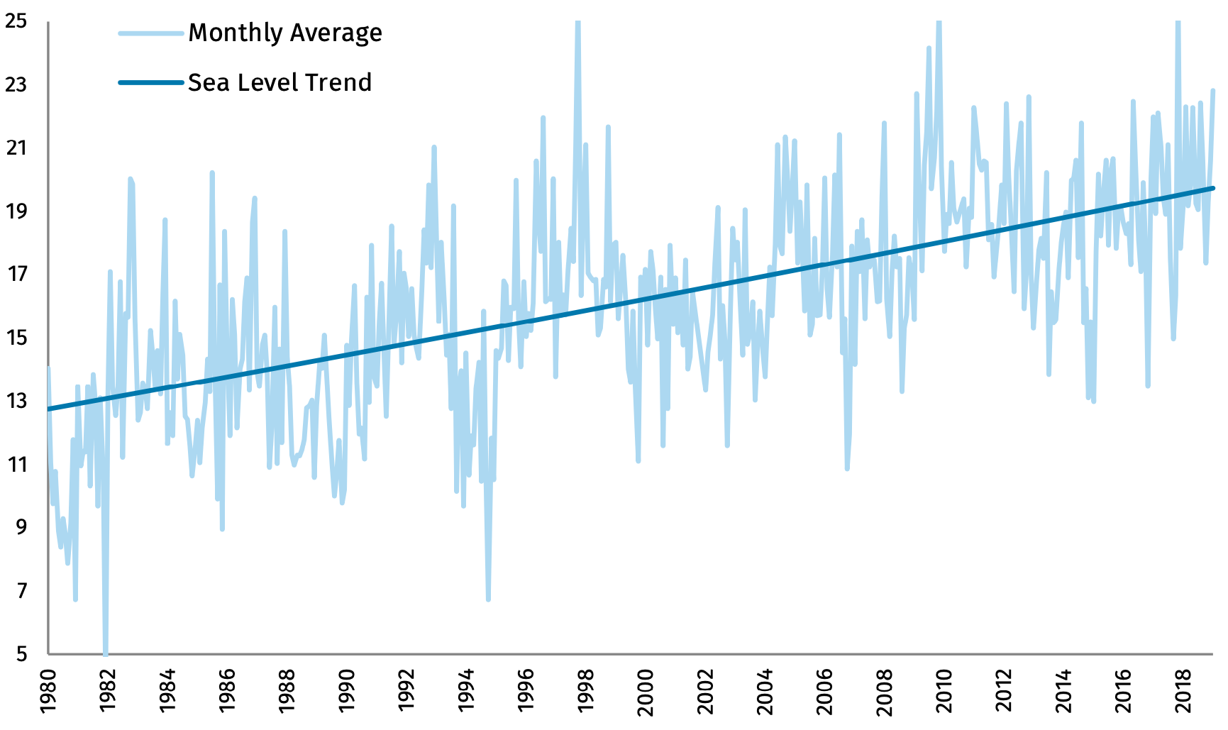
Fig 01: Mean-sea level in inches w.r.t. 1912 in Atlantic City (Source: NOAA)
Let us consider two examples: (a) the New Jersey coast and (b) the pacific northwest. The NJ coast covers 1792 miles of coastline with 17/21 counties in the state. This accounts for approximately 80% of the state’s population and about $400B in annual economic outputs. The changes in sea level and increased hurricane activity have significantly increased the coast’s exposure to storm surges in the past four decades; as shown in Fig. 01, the change in mean sea level in Atlantic City has been almost 16 inches since 1912 and 6 inches since 1980. From 2005 to 2014, there were 235 floods, and of these, 70% have been characterized as “human-caused.”
While it is true that there have been more shark deaths than from tsunamis, this presents an incorrect metric for comparison. Tsunamis are sudden and high-impact events that continue to threaten the livelihoods in coastal communities across the world. It is generally true that an earthquake has initiated most tsunamis. As shown in Fig 02, NOAA estimates that an earthquake triggers about 81% of tsunamis. It is particularly pertinent to note that most tsunamis are believed to be confined to the Pacific region. Yet, it is also relevant to remember that other events like landslides etc. have triggered many mega-tsunamis in other areas of the world. Over the years, there has been some acceptance of the theory that mega-tsunamis are possible but would likely be local events and would diminish to a normal tsunami by the time it reaches the shores.
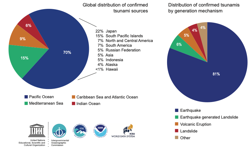
Fig 02: Classification of source and mechanism of tsunami events (Source: NOAA report on tsunamis)
It has become more critical than ever to consider coastal resilience and invest in these endeavours. It is even more important to be prepared for multi-hazard scenarios. Although it is envisioned that future reduction in global emissions could reduce these hazards, this would not be before the second half of the next century, and even that alone will not be sufficient. Therefore, it is necessary to better prepare the vulnerable coastal communities for floods and storm damage.
Causes and timescales
While tsunamis and storm surges are walls of water that reach ashore, causing vast destruction, it is also relevant to briefly touch upon the differences. Though both are driven by different impetus, they are long gravity water waves amplified as they reach the shallow water coasts. So far, the occurrence of tsunamis has been much less compared to storm surges. Tsunamis are often caused due to seismic events and often reach thousands of miles away in a matter of hours. This can be estimated to be 8-10 hours across the pacific during 3-4 hours in the Indian ocean. Over the last decade, a network of early monitoring technologies has been developed for tsunami forecasting. The major ones in operation include:
- Pacific Tsunami warning Center (PTWC) operated by the US NOAA in Ewa Beach, Hawaii for warnings related to the pacific region
- National Tsunami Warning Center (NWTC) in Palmer, Alaska for warnings related to North America
- Indian Ocean Tsunami Warning System (IOTWMS) for warning countries in the Indian ocean region
- North Eastern Atlantic, Mediterranean and Connected Seas (NEAMTWS) to monitor the Atlantic region
Despite these early warning systems, the times are insufficient to consider full-scale evacuation of cities and villages. Hence, large vertical structures have been touted as potential evacuation structures in recent times. As an alternative to horizontal evacuation, vertical evacuation could be potentially feasible. However, as often happens, the tsunami waves can erode the foundation, causing scoring effects (Tonkin et al. (2003) and Roulund et al. (2005)) leading to structural collapse. This makes it even more necessary to consider local scale modelling to understand these wave-structure interactions better.
Further on, such monitoring and learning might not be directly relevant for local mega-tsunamis that are often caused due to seismic or otherwise-generated landslides etc. For example, as shown below in Fig. 03, it is one of the largest waves generated in recorded history. This mega-tsunami was caused due to a seismic-induced landslide in Lituya Bay (Alaska, USA). The recorded earthquake had a magnitude moment of 7.8 – 8.3, generating waves of over 500m (i.e. 1700+ feet) in height. In addition, recent work by Elbanna et al. (2021) discuss unexpected risks from strike-slip faults to generate devastating tsunamis.
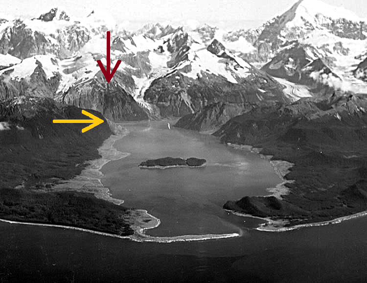
Fig 03: The 1958 Lituya Bay megatsunami at the Lituya Bay, Alaska. The lighter shades at the shores shows the washed out trees; the yellow arrow shows the location of the highest wave; red arrow shows the point of landslide (Image source: D.J. Miller, United States Geological Survey - USGS, Public Domain, https://commons.wikimedia.org/w/index.php?curid=72308974)
In contrast to tsunamis, the storm surge events can be predicted reasonably well in advance to several days based on the forecast of the hurricane's track making landfall. Thus, this often offers sufficient time to evacuate the residents in areas where potential flooding can be expected. Yet, the devastating effects are experienced more often, leading to substantial annual economic losses. The recent hurricane Ida that slammed Louisiana recently presents an excellent example of the nature of such events. The engineers recorded a reversal of the flow of the Mississippi River as a result of the storm surge. Such reversals are not unprecedented but also occurred during hurricane Katrina in 2005 and Issac in 2012.
Local scale mechanics
The primary topic of interest in this article is the discussion on the local scale modelling. The local scale characterization of the coastal hazard is a multi-dimensional problem that includes the structural response to wave loading, debris loading, coastal erosion, sediment deposition, etc.
Regional scale
It would be pertinent to briefly discuss the regional scale event efforts to comprehend the problem thoroughly and how it relates to the local scale modelling. Over the recent years, shallow-water solvers have been used extensively to address regional scale issues related to water inundation and velocity during flooding events. In particular, GeoClaw and AdCirc have been harnessed much in the US. Other commonly used solvers include Delft3D and SLOSH (Jelesnianski, Chen and Shaffer, 1992). These tools can capture wave propagation over entire oceanic basins like the Pacific and Atlantic. They provide acceptable measures for water inundations and velocities. While these tools evaluate the increase in the water level (or surge), storms further include high-frequency local wave effects. Thus, spectral wave models are used with these solvers in a one-way or fully coupled manner. One of the most common modes includes the Simulation Waves Nearshore (SWAN) models that solve for wave spectral density in both frequency and direction (Zijlema, 2010).
Modeling tools and techniques
There are several tools and techniques available to address local scale events. One such example is the work of Harish and McKenna (2021) and Deierlein et al. (2020), i.e. the tool Hydro-UQ. Hydro-UQ is one of the plethora of tools developed at the National Science Foundation (NSF) funded Natural Hazards Engineering Research Infrastructure’s Computational Modeling and Simulation Center (SimCenter) at UC Berkeley. The NHERI SimCenter recently released an extensive state of the art report on computational modelling for natural hazards engineering (Zsarnoczay and Deierlein (2021)) that included contributions from various faculty across the US. In addition, an abridged discussion of the NHERI SimCenter tools was also published recently in the IACM Expressions by McKenna et al. (2022).

Fig 04: Modular SimCenter framework (Source: NHERI SimCenter (Deierlein et al., 2020))
Before discussing Hydro-UQ itself, it is essential to understand the overall framework developed at the NHERI SimCenter over the last half-decade with contributions from various faculty and postdocs. Hydro-UQ leverages the modular application framework, shown in Fig. 04, created at the NHERI SimCenter. The application framework provides a flow for developing regional and local scale models and connecting them to enable damage-loss estimation and compute potential post-disaster recovery. The computational mechanics itself is embedded here in the hazard description and model assets & events. This is further elaborated in Fig. 05, depicting the framework developed at the NHERI SimCenter.
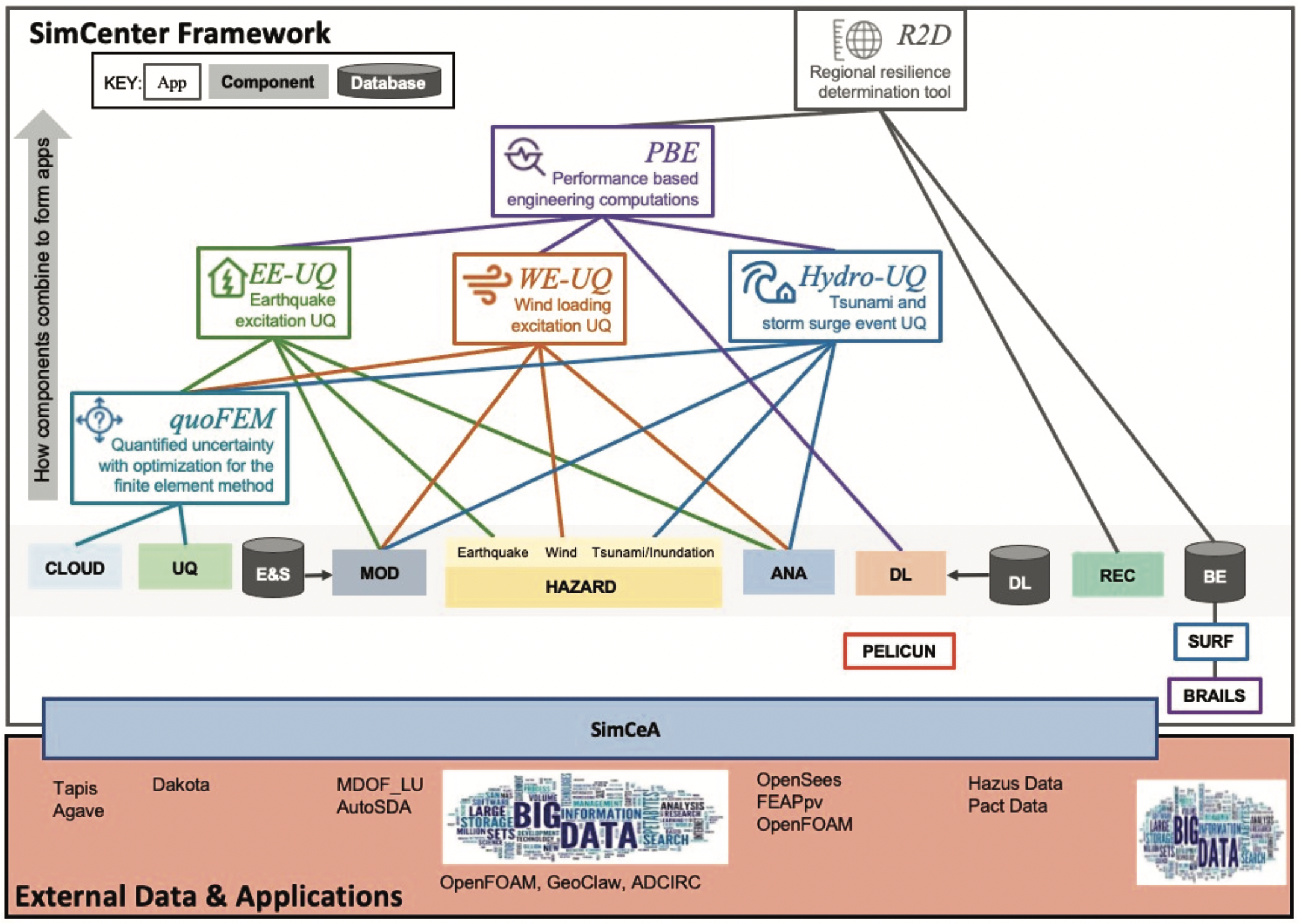
Fig 05: SimCenter framework components and applications (Source: NHERI SimCenter (Deierlein et al., 2020))
The SimCenter workflow, shown in Fig. 05, offers a hierarchical framework that facilitates the usage of Uncertainty Quantification (UQ) rigorously. The UQ engines include Dakota (Adams, 2019), UQPy (Olivier et al., 2020) and SimCenter’s engine (McKenna et al., 2022b) as well. Using an Agave API, simple graphical user interfaces facilitate usage of High-Performance Computing (HPC) resources on the Stampede2 and Frontera clusters of the NSF-funded Texas Advanced Computing Center (TACC). The Agave API itself is an open-source API that can be re-configured for usage on local HPC clusters as well.
This article's tool of direct interest is just one piece of the framework in Fig. 05 that I developed, namely the Hydro-UQ. Hydro-UQ provides a seamless one-way coupling between shallow-water solver (GeoClaw (Berger et al. (2011) and LeVeque, George and Berger (2011))), 3-D Computational Fluid Dynamics solver (OpenFOAM (openfoam.org, n.d.)) and 3-D Finite Element solver (OpenSees (McKenna, Scott and Fenves, 2010)). As shown in Fig. 04, these different solvers are a part of the puzzle pieces and can be easily interchanged with other solvers. For example, changing the shallow-water solver from GeoClaw to AdCirc or ShallowWaterFoam would require an interpreter script along the lines provided for GeoClaw.
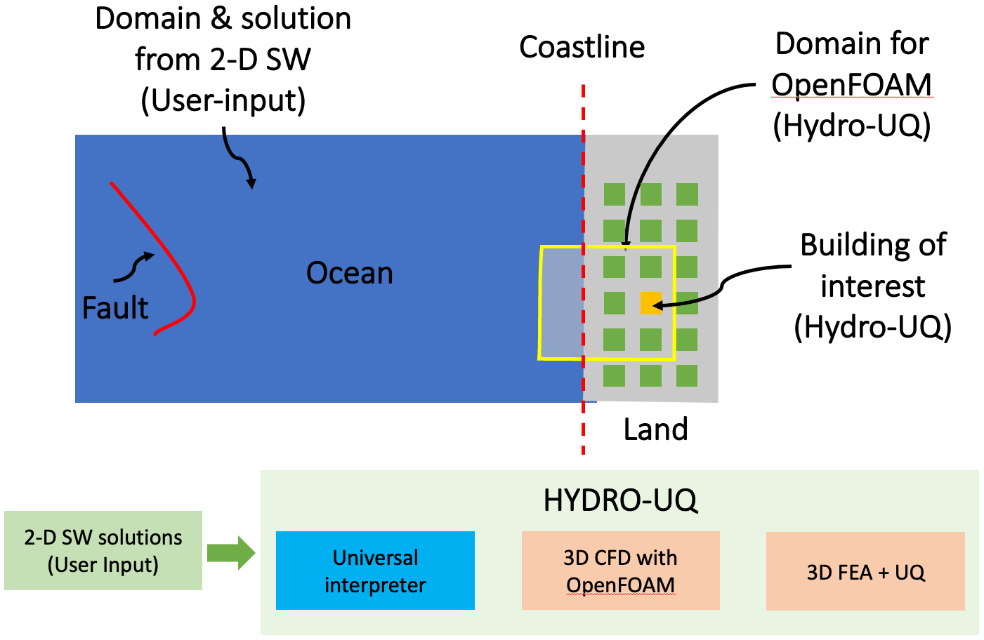
Fig 06: Generic problem of interest in local-scale modeling
Consider a problem of interest, as shown in Fig. 06. Here, the red line represents a fault (in a tsunami) or a low-pressure zone (in a storm surge). The wave propagation problem in large regional scales can be assessed using shallow-water solvers like GeoClaw / AdCirc. At present, Hydro-UQ supports coupling with GeoClaw, but more is envisioned for the future. The orange building represents our building/structure of interest, while the larger yellow box represents our domain for a local-scale CFD analysis.
Pre-computed solutions from the shallow-water solvers are used as boundary conditions for the 3D CFD solver. It is vital to note here that this is a one-way coupling. Thus, the CFD domain needs to be sufficiently large to prevent reflections resulting in unphysical fluid buildup at the boundaries. Next, the computed pressures from the 3-D CFD solutions are applied to the structural models considered for finite element analysis. Here, it is noteworthy that the FEA is coupled with the UQ engine. Here random variables can be defined either in the geometry or material properties, while upcoming versions will also facilitate considering uncertainties in the boundary conditions.
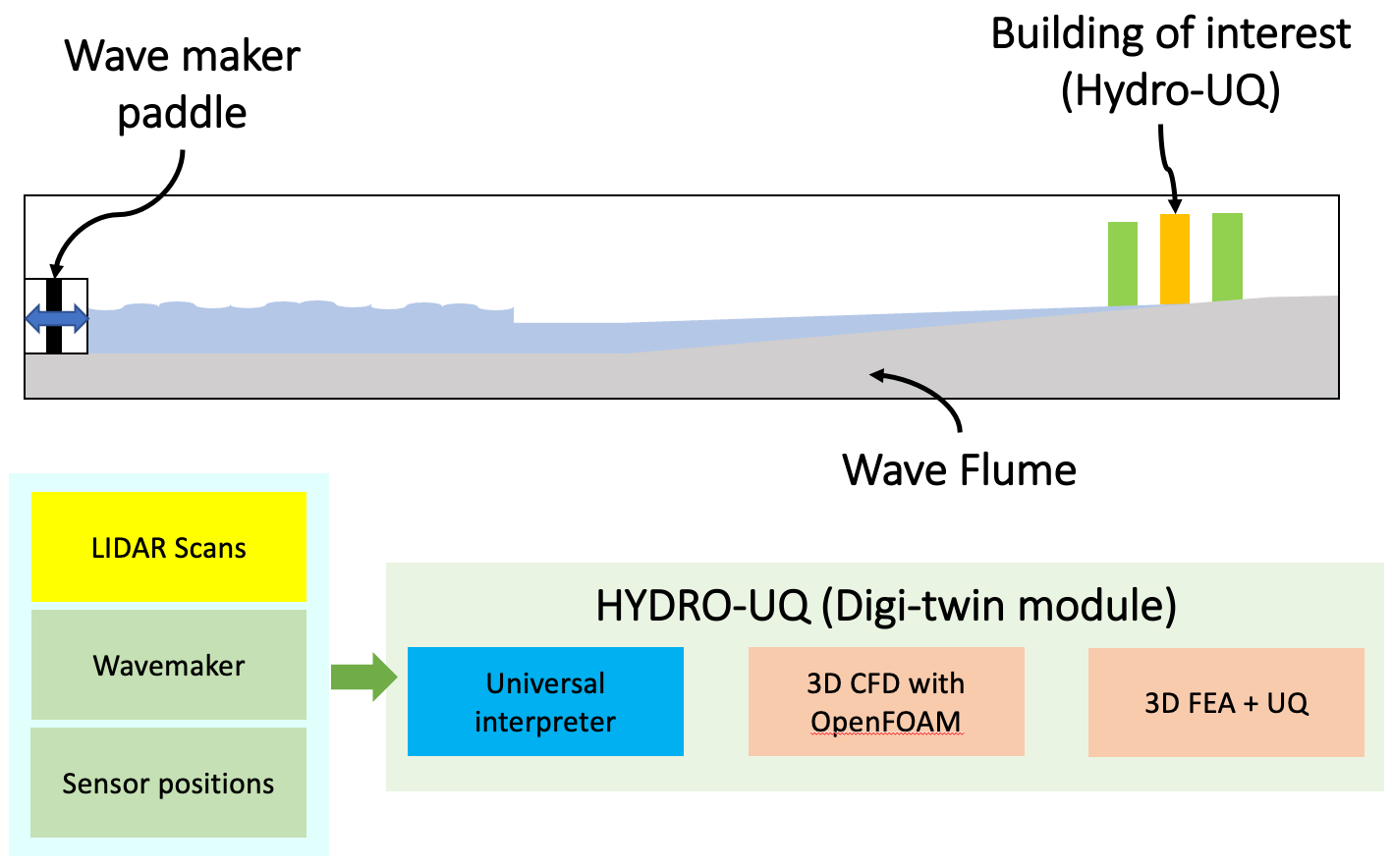
Fig 07: Wave flume digital twin in the Hydro-UQ
One particular aspect of the Hydro-UQ is the wave flume digital twin. The digital twin replicates the wave flume experiments and is based on the large wave flume facility in the O. H. Hinsdale Wave Research Laboratory at the Oregon State University. This wave flume is one of the largest available in North America. The digital twin allows the users to set up the simulation and directly import experimental parameters for usage. The upcoming versions also envision direct support for geometry import through LIDAR scans.
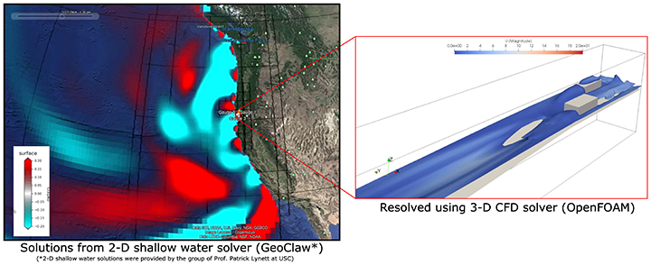
Fig 08: Regional and local scale simulations achieved through one-way coupling of shallow-water (GeoClaw) and 3D CFD solver (OpenFOAM)
Fig. 08 shows an example of the coupling feasible with Hydro-UQ. This example considers pre-computed GeoClaw solutions for an earthquake on the Alaska fault for a moment magnitude of 7.8. The resulting depth-averaged velocities are converted and imposed as 3-D velocity boundary conditions to the OpenFOAM model. For the OpenFOAM model, a small strip of coastal region resembling a flume is considered for analysis. Further on, the pressures from the 3-D CFD simulation are used to obtain story forces for the OpenSees model. Hydro-UQ provides Engineering Design Parameters (EDPs) as its outputs. EDPs can include peak floor displacements, peak floor accelerations etc. Additionally, user can also define their EDPs of interest.
In recent years, this problem of wave-structure interaction has been of great interest. Other tools like OlaFlow (Higuera, 2017) and Reef3D (Kamath et al., 2015) have made it easy to set up wave-structure simulations to quantify the loading on structures using finite volume methods. In addition, alternative meshless methods like Smoothened Particle Hydrodynamics (SPH) and DualSPHysics (Domínguez et al., 2021) offer ways to run on CPUs and GPUs for high-performance computing. An alternative to these includes interfaces like Precice (Bungartz et al., 2016) that help couple tools from various domains and run them seamlessly.
Datasets for comparison
Continuing on the previous Journal article by Emma and the discussion on curating datasets, it would be deemed incomplete if we cannot find datasets for comparison and validation of the developed computational models and tools.
Among others, NHERI DesignSafe (https://www.designsafe-ci.org) offers an easy-to-use and seamless open-source data-sharing repository for researchers in natural hazards. The DesignSafe data repository offers an easy classifier for the shared data in terms of experimental, simulation, field research etc. I would be happy if the readers would share other dataset resources available for unrestricted use by the community for verification and validation.
Challenges and Outlook
This problem of coastal hazards presents a unique multi-disciplinary challenge where computational mechanics can be harnessed to improve coastal resilience. There is a need for bridging methods across solid, fluid and particulate mechanics in a holistic fashion. The issues raised in this journal article are only the tip of the iceberg, while a comprehensive discussion is available in the SimCenter report that has compiled a comprehensive overview (Zsarnoczay and Deierlein, 2021). From a computational mechanics viewpoint, some open problems that can be addressed include:
Wave runup and breaking effects
Many surge models do not simulate the impact of the waves but often only the increase in the elevation. These wave impacts, including breaking effects, etc., are essential in predicting losses in structures. However, these require fine resolution nearshore and are computationally very expensive.
Large deformation Fluid-Structure-Fracture interaction
The most straightforward problem is that there are only a handful of tools and methods that can fully coupled large deformation fluid-structure interaction of structures considering turbulence models. Many state-of-the-art coupling tools like Precice (Bungartz et al., 2016) provide an easy way to bring developments in different domains together. However, even these tools only support small deformation when coupling solid and fluid solvers. Furthermore, many code bases that can do large deformations are often limited to laminar flows.
Debris flows
Considering debris and floating objects and their interaction with waves and structures is a complicated problem. Further on, there is uncertainty regarding the type of debris and its distribution in size and shape. Often, researchers are interested in high-impact events like the impact of a ship or containers in a port. The momentum that these large objects carry could cause significant damage and destruction. Further on, this debris can often break up, leading to much more extensive damage than anticipated.
Multiscale modelling
The problem involves:
- Various levels of abstraction, starting from the meso- and micro-scales of the concrete in the structure.
- Macro-scale structures like the steel frames.
- Local-scale models like the interaction of the wave with 1-3 buildings.
- Regional-scale damage across a neighbourhood or community to a city.
Overall, damage-loss indices and recovery parameters are assessed across the regional scale while materials and structures fail at the micro- and mesoscale. As done in wave flume experiments, it is a unique opportunity to understand the impact of waves and the resulting failure mechanisms in structures.
Turbulence and scouring
Recent papers continue to compare the effect of turbulence models (like k-omega, k-omega SST etc.) on the load measured on the structures. There is a unique opportunity to understand turbulence around a foundation and its effect on scouring and structural stability. There have been several papers in the past, but more collaborative work is required across the fluids and the solids community to relate these to structural failure.
Sedimentation and coastal erosion
One of the most significant issues related to these hazard events, alongside the loss of life and property, remains coastal erosion and loss of land and natural habitats. While wave flume experiments are conducted to understand the transport and settlement of sediments (Holzenthal, Wengrove and Hill, 2022), such problems pose a challenge for our existing computational tools.
Uncertainty quantification
Most often, there are significant uncertainties in the hazard event. These uncertainties can range from the location of the initial seismic (or initiation) activity, wave speeds, and debris in the water to even the micro- and mesoscale properties of the material used in the structure. These unknown factors require careful analysis to understand the characteristics of importance. Sensitivity analysis is easily possible on the structural side by approximating the systems as stick models. However, most fluid simulations are at least an order of magnitude slower and render capturing these uncertainties much harder.
Application of machine learning
The recent hazard events have led to large datasets in terms of videos and photos from drone surveillance. While it is infeasible to parse them manually, machine learning (ML) provides a unique opportunity to better comprehend the uncertainties in these extreme events. Furthermore, these ML models can help quantify sensitive parameters as learning to better focus the efforts towards developing computational mechanics algorithms.
Communication between various communities
The biggest challenge remains that this multi-disciplinary problem requires a more concerted effort across the board. There is a need for more communication between engineers, computational mechanicians, geophysicists etc., to tackle the problem collaboratively.
References
Adams, B.M. (2019). Dakota, A multilevel parallel object-oriented framework for design optimization, parameter estimation, uncertainty quantification, and sensitivity analysis: Version 6.11 user’s manual. Sandia Technical Report: SAND2014-4633.
Berger, M.J., George, D.L., LeVeque, R.J. and Mandli, K.T. (2011). The GeoClaw software for depth-averaged flows with adaptive refinement. Advances in Water Resources, 34(9), pp.1195–1206. doi:10.1016/j.advwatres.2011.02.016.
Bungartz, H.-J., Lindner, F., Gatzhammer, B., Mehl, M., Scheufele, K., Shukaev, A. and Uekermann, B. (2016). preCICE – A fully parallel library for multi-physics surface coupling. Computers & Fluids, 141, pp.250–258. doi:10.1016/j.compfluid.2016.04.003.
Deierlein, G.G., McKenna, F., Zsarnóczay, A., Kijewski-Correa, T., Kareem, A., Elhaddad, W., Lowes, L., Schoettler, M.J. and Govindjee, S. (2020). A Cloud-Enabled Application Framework for Simulating Regional-Scale Impacts of Natural Hazards on the Built Environment. Frontiers in Built Environment, 6. doi:10.3389/fbuil.2020.558706.
Domínguez, J.M., Fourtakas, G., Altomare, C., Canelas, R.B., Tafuni, A., García-Feal, O., Martínez-Estévez, I., Mokos, A., Vacondio, R., Crespo, A.J.C., Rogers, B.D., Stansby, P.K. and Gómez-Gesteira, M. (2021). DualSPHysics: from fluid dynamics to multiphysics problems. Computational Particle Mechanics. doi:10.1007/s40571-021-00404-2.
Elbanna, A., Abdelmeguid, M., Ma, X., Amlani, F., Bhat, H.S., Synolakis, C. and Rosakis, A.J. (2021). Anatomy of strike-slip fault tsunami genesis. Proceedings of the National Academy of Sciences, [online] 118(19). doi:10.1073/pnas.2025632118.
Harish, A.B. and McKenna, F. (2021). NHERI-SimCenter/HydroUQ: Version 1.0.0. [online] Zenodo. Available at: https://zenodo.org/record/4731074#.YpazOGDMIqs [Accessed 1 Jun. 2022].
Higuera, P. (2017). olaFlow: CFD for waves softwre. doi:10.5281/zenodo.1297013.
Holzenthal, E.R., Wengrove, M.E. and Hill, D.F. (2022). Mechanisms of sediment transport around finite patches of submerged aquatic vegetation. Estuarine, Coastal and Shelf Science, [online] p.107905. doi:10.1016/j.ecss.2022.107905.
Jelesnianski, C.P., Chen, J. and Shaffer, W.A. (1992). SLOSH: Sea, lake, and overland surges from hurricanes. https://www.nhc.noaa.gov/surge/slosh.php.
Kamath, A., Alagan Chella, M., Bihs, H. and Arntsen, Ø.A. (2015). Evaluating wave forces on groups of three and nine cylinders using a 3D numerical wave tank. Engineering Applications of Computational Fluid Mechanics, 9(1), pp.343–354. doi:10.1080/19942060.2015.1031318.
LeVeque, R.J., George, D.L. and Berger, M.J. (2011). Tsunami modelling with adaptively refined finite volume methods*. Acta Numerica, [online] 20, pp.211–289. doi:10.1017/S0962492911000043.
McKenna, F., Schoettler, M., Deierlein, G.G. and Govindjee, S. (2022a). Simulation in natural hazards engineering and the SimCenter. IACM Expressions.
McKenna, F., Scott, M.H. and Fenves, G.L. (2010). Nonlinear Finite-Element Analysis Software Architecture Using Object Composition. Journal of Computing in Civil Engineering, 24(1), pp.95–107. doi:10.1061/(asce)cp.1943-5487.0000002.
McKenna, F., Yi, S., Satish, A.B., Zsarnoczay, A., Gardner, M., Zhong, K. and Elhaddad, W. (2022b). NHERI-SimCenter/quoFEM: Version 3.0.0 (v3.0.0). [online] Zenodo. Available at: https://doi.org/10.5281/zenodo.6404498.
Olivier, A., Giovanis, D.G., Aakash, B.S., Chauhan, M., Vandanapu, L. and Shields, M.D. (2020). UQpy: A general purpose Python package and development environment for uncertainty quantification. Journal of Computational Science, [online] 47, p.101204. doi:10.1016/j.jocs.2020.101204.
openfoam.org. (n.d.). OpenFOAM v7 | The OpenFOAM Foundation. [online] Available at: https://www.openfoam.org [Accessed 1 Jun. 2022].
Roulund, A., Sumer, B.M., Fredsoe, J. and Michelsen, J. (2005). Numerical and experimental investigation of flow and scour around a circular pile. Journal of Fluid Mechanics, 534, pp.351–401. doi:10.1017/s0022112005004507.
Tonkin, S., Yeh, H., Kato, F. and Sato, S. (2003). Tsunami scour around a cylinder. Journal of Fluid Mechanics, [online] 496, pp.165–192. doi:10.1017/S0022112003006402.
Zijlema, M. (2010). Computation of wind-wave spectra in coastal waters with SWAN on unstructured grids. Coastal Engineering, 57(3), pp.267–277. doi:10.1016/j.coastaleng.2009.10.011.
Zsarnoczay, A. and Deierlein, G.G. eds., (2021). State of the Art in Computational Simulation for Natural Hazards Engineering (Version v2). http://doi.org/10.5281/zenodo.4558106: Zenodo.
| Attachment | Size |
|---|---|
| 248.25 KB | |
| 111.92 KB | |
| 416.9 KB | |
| 261.47 KB | |
| 1.39 MB | |
| 2.97 MB | |
| 143.36 KB | |
| 113.21 KB |
- Ajay B Harish's blog
- Log in or register to post comments
- 4319 reads


Comments
Scope of the subject
This article brilliantly describes how computational techniques could be used for modelling disasters and subsequently minimising the damage caused by these phenomena. For those who had attended the online training conducted by the author at designsafe this article could be a summary of all what they had learnt then. I wish the author conducts even more training sessions on Hydro-UQ so that the student community realises its true potential